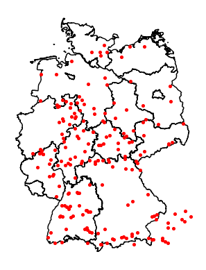
Spa towns starting with "Bad" and OSM
A few days ago I was sitting at a train station in Bad Wildbad waiting for a train home because of a flat tire on my bike. I was thinking about spa town distribution and cities which name starts with "Bad" (German for "bath") which is a pretty solid indicator for a spa town in Germany. Of course there are many spa towns in Germany that don't start with "Bad". Probably they could be collected via a wikidata query on subclass of spa town but I wanted to solve this with Openstreetmap only.
To get the datasets of all cities, towns, villages and suburbs starting with "Bad" we use the same Python code as in a previous blogpost about the overpass api. The changes needed are:
City names can be in nodes or ways (ways contain the borders of the city). Nodes seem more common so limit to those. The selector "name" should start with "Bad " and "place" should be limited to a list of town-link places. The query with a trailing space will filter out "Baden Baden", but also some false positives, i.e. Badevel, Badonvilliers-Gérauvilliers and a few more.
The query result is messy. A few cities are duplicates (i.e. Bad Salzuflen; Bad Sooden, Bad Sooden-Allendorf - both town vs. suburb). But removing all "suburbs" will remove a lot more valid cities. Without manual work this will not be without error.
Three examples of nodes returned show that the attached tags differ a lot:
First: A way should be used; I ignore them for now. This city will have empty metadata.
{
  "type": "node",
  "id": 25728642,
  "lat": 50.2276774,
  "lon": 9.3485142,
  "tags": {
    "name": "Bad Orb",
    "note": "Alle Daten der Stadt Bad Orb sind in der zugehörigen Grenzrelation. Dieser node dient nur zur Markierung der Ortsmitte.",
    "place": "town"
  }
}
Second: The fields have no prefixes. Kind of what I expected and most cities look like this.
{
  "type": "node",
  "id": 26120920,
  "lat": 51.5911653,
  "lon": 12.5856428,
  "tags": {
    "ele": "98",
    "name": "Bad Düben",
    "place": "town",
    "population": "8000",
    "postal_code": "04849",
    "website": "https://www.bad-dueben.de",
    "wikidata": "Q12041",
    "wikipedia": "de:Bad Düben"
  }
}
Third: A lot of extra fields prefixed with OpenGeoDB. I ignore this fields and hope the other fields are filled good enough.
{
  "type": "node",
  "id": 21635999,
  "lat": 47.5062921,
  "lon": 10.3699251,
  "tags": {
    "ele": "825",
    "name": "Bad Hindelang",
    "openGeoDB:community_identification_number": "09780123",
    "openGeoDB:is_in_loc_id": "270",
    "openGeoDB:layer": "6",
    "openGeoDB:license_plate_code": "OA",
    "openGeoDB:loc_id": "13927",
    "openGeoDB:telephone_area_code": "08324",
    "place": "town",
    "population": "4899",
    "postal_code": "87541",
    "wikidata": "Q522573",
    "wikipedia": "de:Bad Hindelang"
  }
}
The resulting list of elements is then converted into a Pandas Dataframe:
df = pd.DataFrame.from_records(
    [
        # all fields, excluding "tags"
        {k:v for k, v in d.items() if k != "tags"}
        # merge tags to toplevel
        | {k: v for k, v in d["tags"].items()}
        for d in data
    ]
)
Next we want to find out which tags are mostly filled:
# sum emptiness of fields; subtract from number of rows and sort by highest number
print(
    dict(
        pd.isna(df)
        .sum(axis=0)
        .apply(lambda x: len(df) - x)
        .sort_values(ascending=False)
    )
)
The most common ones are as expected the essential parts of the query:
"place": 237,
"name": 237,
"lon": 237,
"lat": 237,
"id": 237,
"type": 237,
"population": 165,
"wikidata": 158,
"wikipedia": 124,
"postal_code": 62,
From 237 datasets 158 datasets have a link to Wikidata and 124 one to Wikipedia. And even less have a postal_code. One could argue that this information could be found elsewhere. But it would be convenient to have the population filled or a wikidata link to query more information.
Finally lets use the code from the previous blogpost to plot all the spa cities starting with "Bad " on a Germany map. As seen on the plot, some spa cities are in Austria or in Switzerland because the bounding box used in the query is a rectangle and not the exact borders of Germany.
